
TADERA is a DBA (doing business as) firm for the long-recognized GCR, Inc. This firm was originally founded in New Orleans in 1979, with a focus on engineering and urban planning. This mix of disciplines quickly lead to a specialization in airport planning, engineering and consulting. The firm, however, was always innovative and pushed the technological envelope. In 1982, the firm developed a concept called Photoslope for evaluating runway approach surfaces to determine if any obstructions penetrated the imaginary surface of the approach.
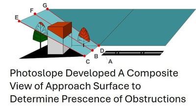
This process used a combination terrestrial surveying techniques with photogrammetric processes to develop a composite view of the imaginary approach surfaces. In March of 1982, a pilot program at the New Orleans International Airport to determine the viability of the analysis. The results were promising.

A few months later, in July of 1982, Pan Am flight 759 experienced windshear at New Orleans International Airport and tragically crashed into the surrounding community. The initial proximal cause appeared to be tree obstructions at the end of the runway, since the plane hitting a tree line is what ultimately brought it down. Because of our pilot program analysis a few months earlier, we were able to demonstrate that the trees were below the approach surface, and not a hazard.
This incident highlighted the need for airports to assess their approach surfaces and ensure that they are clear obstructions. As a result of this, our firm was commissioned throughout the country to conduct Photoslope airspace analysis at airports of all sizes. Over the next decade, GCR accomplished Photoslope analyses over 850 airports and at over 3,200 runway ends.

In 1985, the FAA, having received scores of reports delivered in box after box, an FAA manager offhandedly suggested that we should just put it on a computer. Even though visual Windows-type technology was only on the bleeding edge at the time, this is exactly what we did. This was the beginning of our first airport computer program, called Airport Information Management System (AIMS). The AIMS system grew quickly, eventually becoming the standard platform for 34 state aeronautics departments and airports across the United States.
FAA 5010 Program

A second fortuitous event occurred in the late 1990’s that launched our FAA and national aviation practice. Within the National Flight Data Center (NFDC) of the FAA, a larger tractor-feed printer used to print all 5010 documents for distribution to state aviation agencies, FAA inspectors, and individual airports because inoperable. The FAA was now unable to print and distribute this critical report. Spotting an opportunity to help the industry, GCR created a program with the latest airport data and distributed it on a 3.5” floppy disk package, so users could print directly to their printers. This program was then placed on the web, and became the first time airports and state aviation agencies had direct digital access to their airport information. This was a highly visible industry event and positioned us well to start a long standing and productive relationship with the FAA.
Although we started small four decades ago, a legacy of innovation and technological leadership continues to this day.